The blog of the Hawai'i Museums Association. HMA is a non-profit corporation dedicated to communication and cooperation among the staffs and supporters of Hawaii's museums.
Thursday, November 15, 2012
Honolulu Public Art Finder by E. Tory Laitila
In June 2012, the Honolulu Mayor’s Office of Culture and the
Arts (MOCA) introduced its first smart phone app. MOCA, in conjunction with the
City and County of Honolulu Department of Information Technology (DIT) and Code
for America, developed this application. Available for both smart phones and
computers, it gives users a real time map showing the placement and descriptions
of specific works from Honolulu’s
Art in City Buildings collection.
 |
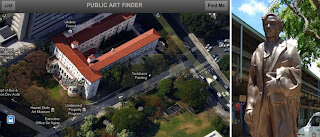
Public art, such as this plaster sculpture of
Jose Rizal,
can be found on a new iPhone app developed for Honolulu.
|
Initially DIT approached MOCA about developing an iPhone app
to view Honolulu’s
Art in City Buildings collection. The collection at that point was only
publicly accessible through the MOCA webpage via PastPerfect online. The app
would be a stand alone iPhone application that could access mirrored data from
the MOCA PastPerfect museum software database providing direct access to information
on the entire collection.
When Code for America joined the City in its goal to develop interactive applications, the design for the Art in City Buildings collection app changed. Instead of merely accessing MOCA’s PastPerfect data, the new app would plot the position of the publicly accessible works of art on a map. Similar to Google Maps, to which MOCA had slowly been adding public art sites, this app would provide a visual guide to the locations of Honolulu’s art works.
The information for the app was provided by exporting data from
MOCA’s PastPerfect database. In order to get an accurate location to plot on
the map, each object needed exact longitude and latitude coordinates. The
entire collection was sorted and a new PastPerfect data field created, “Public
Art Access.” Works that were identified with “full” or “limited” public art access
had longitude and latitude coordinates acquired and entered in the database.
After this lengthy process, information on “full” and “limited”
publicly accessible works of art was exported and utilized by Mick Thompson, a 2012
Code for America fellow, to create the app. Using the colors from the MOCA
logo, flag points are shown on a map of the locations of the works, selecting a
flag will show the title of the work with a thumbnail image, and if selected again
will open a new page that details the title, an image, object name, a
description, date, and any donor information. The app can also be used in a
list view and will show the user the closest works to their location.
Check out the MOCA Public Art finder at http://art.honolulu.gov.